Friday, October 11, 2019

Hoodoo You See?


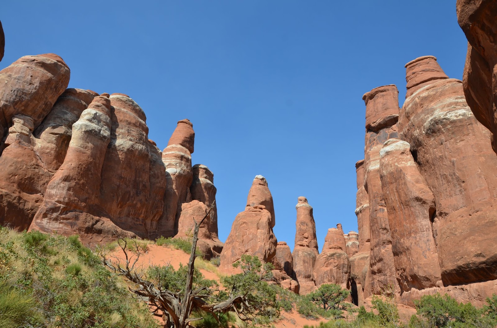
After several days based in Moab, we ventured further west, following I-70 (again) through Utah. Disconcertingly, flurries began not long into our drive and continued for the next several hours. It was time to face the facts: the temperature was below freezing and would be so for the next couple of days of our trip. We continued on to Bryce Canyon, land of the hoodoos. The term hoodoo refers to “tall, thin spires of rock protruding from the bottom of an arid drainage basin or badland”. Many of them are formed of soft stone with a top crust of harder stone that partially shields the top from erosion, even as the sides wear away. Nowhere are the hoodoos more plentiful than in Bryce Canyon, Utah.

On arriving to Bryce, we headed out on the Navajo Loop-Peekaboo Loop combo trail within the Bryce Amphitheater, which started off with a steep descent from a stunning outlook to the base of the basin.


Manmade switchbacks were the only thing softening the descent down hundreds of feet.

The steep, sheer cliff faces rose up around us on the Navajo Loop, but it was on the Peekaboo Loop that we got to get up close to the hoodoos of various sizes. Those at the top of the cliffs were scraggly, worn nearly to nothing, while beefier hoodoos decorated the lower parts of the basin.

We saw several familiar windows and arches, including one well-marked point of interest called Two Bridges consisting of two rather puny small arches that, well, weren’t very impressive after several days at Arches. They were no Delicate Arch, if you get what I mean (this coming from a newly minted arch-viewing expert). Still, the hoodoos alone are enough reason to visit Bryce. Plus, with the short distance from parking lot to trail and several shorter trail offerings (albeit with a lot of elevation change), the place was crawling with families. It was also the first place we saw some visitors testing the limits of their wheelchair motors as they sped along the rim trail. We also saw several under-four children near the point of exhaustion tantrum on the ascent back up to the parking lot, but everyone seemed to be managing.

After completing the aforementioned loops, we walked the canyon rim to Inspiration Point, an overlook offering unmatched views of the canyon. The sheer number of hoodoos, stretching for miles in fairly neat rows, made the whole area look like a rippling series of stones.


Bryce Canyon also offers a series of viewpoints along the paved stretch down the middle of the plateau. We stopped at two – Natural Bridge and Rainbow Point. Natural Bridge was yet another arch; apparently it was misnamed because bridge refers to a different geologic creation process. It was quite beautiful, although one spindly section at the right edge made us wonder how long it would last (in relative terms… nothing is likely to happen in the next several thousand years).

Rainbow Point offers a look over the whole canyon and surrounding valley.  It also has signs describing the flora and fauna of Bryce Canyon, some of which we were sorry to miss (flying squirrels) while others we could do without (rattlesnakes, mountain lions).

Another day, another park visited. We are officially halfway through our trip!

Spotted: Rural life. A small town (dubbed Bryce Canyon City) had sprung up just outside the park, with a sign announcing that it was founded in 2007. The next closest town was about 15 miles away and the main street ran about 100 yards. On our morning drive to Bryce, spots to stop and refill our gas tank were often 50-60 miles apart. The only music here is country music, and roadside establishments have names ranging from the cutesy (Mugglewumps) to celebrations of a wild west past (Outlaw Saloon – the mascot holding a pistol in one hand and a serving tray in the other, of course with a cowboy hat). Gas station snack selections include Idaho Spuds (a marshmallow-chocolate-coconut confection) and Muddy Buddies. Horses, sheep, and cows are more plentiful than people, and dwellings are modest. Décor involves a lot of old tractor parts, farming equipment, and vintage milk cans. Having only visited places this rural rather than lived in them, it certainly feels like a different world from the one I have known.

Wednesday, October 9, 2019

Take Me to That Island in the Sky

We awoke before dawn and drove through the darkness, passing Arches National Park on our way to its nearby sister – Canyonlands. We pulled into the parking lot by Mesa Arch (a part of the Island in the Sky portion of the park) just as the first hints of light were touching the sky and hustled by flashlight to the overlook. More than a dozen serious photographers had beaten us there, tripods set up and positions staked. There was still the occasional jockeying when a new photog arrived, shuffling in front of another’s lens to snap “just a few pictures” before being shamed to the back of the pack. Being very far from a serious photographer myself, I snapped the odd pic from between the others’ shoulders and settled in with Josh atop a large boulder nearby. I had heard people talk about Canyonlands as a smaller version of the Grand Canyon, but that doesn’t give it enough credit. It was possibly the most beautiful sunrise I have ever witnessed.


After the sun had assumed its position, we returned to the car and drove though the gorgeous park. 


At last, we reached Grand View, which is a perfect place to crawl to the edge and swing your legs over to marvel at the cracks in the earth below. Then, of course, you must do the rim walk to see all the strange columns and formations below from every imaginable angle. It’s hard to believe that water has shaped the earth in so many different ways – in this case, trickles of water freezing and cracking apart long lines of stone. You can see the white rim of sandstone at the edges of the canyons below, Monument Basin where the valley has fallen down, and vertical spires of eroded sandstone in clusters or alone (as in the case of Totem Pole) dotting the basin. There were so many layers of earth that had risen or fallen away.


Our final stop in Canyonlands was at Upheaval Dome. On the hike up, Josh and I guessed at its origins. I favored the salt dome theory that we had learned at Arches, while Josh hypothesized a meteor strike. It turns out these are the two leading theories of the scientific community, as well, although the meteor theory has recently come into greater favor. The hike out to the First Overlook was rather routine, but the hike to the Second Overlook required a good bit more rock scrambling in large wind gusts than either of us had anticipated – and for a rather underwhelming view (everything’s relative, of course).


For the afternoon, we drove back to Arches National Park, since we had secured a pass to the Fiery Furnace.

This cluster of rims and columns for a long time had no official path and required a guide, as it was quite easy to become lost. They have since done away with guided tours and created a minimally marked 2-mile loop through the Furnace, though they still warn you to be able to navigate your way out independently. Josh and I were also asked if we were bringing in rope, to which we responded, “Should we?” Apparently much hardier adventurers sometimes rappel down the sheer cliff faces to explore otherwise unreachable crevices. We were fully aware of our beginner status and were fine taking only brief side jaunts off of the counterclockwise path. To obtain our pass, we had to watch a 20-minute video that essentially told us to pack out our waste (including human waste, and the visitor center store conveniently sells bags designed for this purpose) and not disturb the sacred biological crust, home of all microbial activity and birthplace of all Furnace life (all kidding aside, it's very important).
A picture of the biological crust in action.
On arrival to the Furnace, we learned that when they said the path was minimally marked, they took their minimalism seriously. A three-inch white arrow encountered every 20 minutes or so was meant to suffice. This left many a turn unmarked, something that didn’t become a serious problem until about two-thirds of the way through the loop. We encountered two other groups who had paused at a flat area, one to lunch and one out of confusion. The path forward was indicated by one arrow, but after passing it there was no clear way forward. Working with our new supergroup, Josh and I scrambled down each direction, only to meet 50-foot drops that ruled the potential pathways out. I scrambled around a corner of bare rockface, much to Josh’s horror, and he quickly called me back. In the end, it was the father from one of the other groups who discovered the path and the next arrow almost by accident. It did include rounding that corner of bare rockface and then passing into the darkest rock crevice encountered thereafter. Perhaps one more arrow would have helped.


Josh and I hiked onward, relieved we wouldn’t have to retrace our steps to get out of the park alive and now in the company of an older and very adventurous couple. It was fun to have hiking companions, and we passed the remaining time in the Furnace in happy chatter. We also encountered an experienced Furnace hiker who told us of a secret path, a place where you passed the “Dead End Ahead” sign and continued on to a secret arch. We followed his instructions and, just like he said, a new path emerged, tidily bordered with small stones. We saw the shadow of the arch before the arch itself, as it was round yet another corner. But there it was, a hidden gem of the Furnace.


The remaining hike out of the Furnace was the now-standard mix of hiking, hewn steps, and precarious rock scrambling. The path gave itself up without much fuss and the high walls of rock remained absolutely unimpressed by our presence.


A few reflections on Arches and Canyonlands National Parks as this leg of our trip comes to a close:
- Arches: a driving-based park that is extremely impressive with varied hikes. The arches are beautiful; visit all the named ones, but particularly Delicate Arch. Fiery Furnace offers a different kind of adventure, but a welcome one (if you don’t mind scrambling up rocks and a more strenuous adventure). Tickets sell out daily, even in October, so plan to purchase them the day before, preferably in the morning.
- Canyonlands: also a driving-based park. The sunrise at Mesa Arch can’t be beat, and the rim walk by Grand View is wonderful (although with a few tall steps that could be difficult for younger kids). The hike by Upheaval Dome out to the two Viewpoints was a bit underwhelming. Additionally, there was a fair amount of scrambling up smooth rocks in some serious wind gusts, which is not for the fear-of-heights-prone. The longer hike around the other side of the rim sounded daunting, and I can’t imagine the views from there would be worth it given the low-hanging riches to be had elsewhere in the park. Josh and I both felt that a morning at Island in the Sky (the third of the park we visited; each third has to be accessed completely separately and the other two are more ATV-exploration-based) was the perfect taste.


Spotted: Utah highway signs have the highway number inside of a beehive. Apparently, early Mormon settlers felt the beehive represented hard work and industriousness and felt that the cooperation of the bees in constructing something much bigger than themselves was a model for a properly run society.

And my usual extra picture:

Tuesday, October 8, 2019

With an Arch Smile


Today was all about the arches. Arch mania, one might say. We started with Delicate Arch, which has become a symbol of Utah and ornaments the Utah license plate (so we had seen it a lot before today). 
It’s the largest free-standing arch in the park and is worth all of the gently-sloping-hope-I-don’t-slip terrain you traverse to get there. Apparently, it has had more colorful names in the past, including Cowboy’s Chaps, Old Maid’s Bloomers, and Salt Wash Arch. In 1934, an article described it as “the most delicately chiseled arch in the entire area” (more on that later) and the arch was born again.
For scale, see the tiny humans
After Delicate Arch, we headed to the area by Devil’s Garden Campground to see the Sand Dune Arch and Broken Arch. Sand Dune Arch is nestled in the narrow opening between two tall sandstone fins. 
Gigantic entrance slabs
Sand Dune Arch
We learned from the handy signs at the trailhead that these narrow fins of stone are the result of inflexible stone breaking as the huge piles of salt beneath it bulge upward. 
The Salt Valley between fins of stone represent places that the underlying salt dissolved when water seeped in, causing overlying rock to crash down and then be worn smooth. 
The colorful Salt Valley
Neither Josh nor I have any real idea how this was figured out, but a big shout out to the geologists that make this knowledge possible. After Sand Dune Arch, we meandered over to Broken Arch. 
The first thing that everyone likes to point out about Broken Arch is that it isn’t really broken. There is a crack along one edge, but the arch looks mighty stable and there’s no gap. While admiring this beauty, Josh and I met an adorable elderly couple from Colorado who added additional items to our Future Vacation To See List and showed us exactly who we want to be in another 50 years.

Last but not least, Josh and I hiked out to Landscape Arch. 
According to park signage, Landscape Arch is the 3rd largest natural arch in the world, although the Natural Arch and Bridge Society (NABS) begs to differ. But who really cares? It’s really big and really impressive. My biggest issue with the whole thing was that Landscape Arch seems much more delicate than Delicate Arch. Of course, Landscape Arch lost some serious weight in the mid-‘90s when a few large rockfalls slimmed down its silhouette and forced the National Park Service to close the train beneath it. Pictures from a better angle really drive home how thin the Landscape Arch has become.

Well, is Arches National Park on your Travel To See List yet? If you still need more convincing (seriously?), stay tuned for one last Arches adventure tomorrow.

Spotted: Ravens! Our hometown birds are all over the place, looking all regal and fierce. As Josh and I realized after a recent trip to the zoo (beyond that the Baltimore Ravens do sponsor the Maryland Zoo ravens), ravens are pretty big, magnificent birds.


And one more pic just because:

Car Appreciation Day

Warning: gratuitous use of photos ahead.

We left Denver, realized just how big the state of Colorado is, and were completely dumbstruck by the beauty (and variety) of the landscape unfolding before us. There were molded hills of smooth stone, jagged cuts through rock exposing every layer - red, tan, brown. And even within those colors, you saw the entire rainbow as you got close enough – red bushes, green shrubs, yellow grasses, blue hints in the stone face. For a long while, the highway followed the river as it wound through a cut between the cliff faces. We couldn’t help but think about the importance of mountain passes back in the day (mostly in the context of elementary school Oregon Trail games, if we're being honest). The cliffs would have been daunting (but really impossible) in a wagon. As we crossed each mountain line, we noticed another thing that hasn’t changed – each valley offered a sudden flourish of buildings, like an outpost town, ready to supply you with provisions, hardware, and a place to rest, while between them lay long stretches of raw, rocky land. Who owns all those open square miles? Another fun sighting was the "2 Kool 4 Skool" bus, which we had seen the day before parked outside Rocky Mountain National Park. We looked it up, and it turns out it's a school bus converted over the past year by a family with some serious wanderlust. 
Can you spot our pika friend enjoying the view?
A few hours and hundred miles later, we settled into our new lodging in Moab, Utah and set out to explore the small town. To say the town is geared toward tourism is an understatement, as the annual number of visitors has climbed to 3 million and the number of tourist lodgings has increased by more than 50% in the last 5 years. This, of course, is largely driven by the visitors to Arches National Park and Canyonlands National Park.
Begrudging husband is begrudging
Interestingly enough, though, it’s also a college town, home of Utah State University Moab. College in Moab would have been a very different experience than the one I had in a New England college town-city hybrid – one spent breathing in the outdoors, perfecting mountain biking skills, and studying in the reflection of the red rocks. Which leads me to our next realization: though Josh and I plan to hike here, it seems that the cool thing to do is mountain bike. As we meandered through the small downtown and stopped for a bite to eat (at the one and only Quesadilla Mobilla), all of the buzz at surrounding tables was about wheels and miles and bike trails. Guess that's on the agenda for our next trip out here (with every place we stop, our future trip to do list grows longer).

Still, there’s plenty for the hikers. In the evening, we headed to Arches National Park to take in a couple of the more accessible viewpoints and catch the sunset. Driving into the park makes you feel like you can’t look enough directions at once. There’s too much to see, too much to miss. Eroding columns of rock look like animals, faces, or monuments depending on the angle and the lighting. We passed Park Avenue, La Sal Mountains, Courthouse Towers, and so many more whose whimsical names didn't make the map.


We stopped at Balanced Rock, a piece of stone that weighs as much as 1,300 cars and sits nearly as tall as the Statue of Liberty. Formed from harder stone sitting atop an eroding layer of mudstone, Balanced Rock is doomed. 
Its smaller sidekick (the aptly named Chip off the Old Block) toppled 40 years ago and Balanced Rock's own clock has been ticking ever since. From there, we headed to The Windows, hiking the “primitive trail” around its periphery. We saw Turret Arch glowing in the light of sunset and settled in to watch our burning star fall below the horizon.
The North and South Windows
Stranger standing in Turret Arch

Of course, when we got home and met the father and son sharing our AirBnB, they told us they biked “the whole enchilada” – which turns out to be a trail called The Whole Enchilada.

Spotted: Runaway truck ramps. During a seven-mile stretch of seven-degree downhill, the highway shoulder was punctuated with regular runaway truck ramps. If your brakes overheat or fail, you pull onto the steep upward ramp until all of your kinetic energy becomes potential energy… and you can finally stop panicking. 

Monday, October 7, 2019

Give Me Shelter


Well, our long-awaited vacation has finally arrived, and we are thrilled to have escaped to the West. We landed in Denver on Saturday evening, enjoyed a stroll around Larimer Square (cute but smaller than expected), bought an enormous amount of provisions, and settled down for a good night’s rest before our first big day. Our first impression of Denver is mostly a shock at how new everything is. Around Larimer Square is a small cluster of older buildings, including one labelled “1886”, as well as some single-story brick shops that now look oddly out of place, as they are just down the road from towering skyscrapers and the enormous modern performing arts center with its sky-high dancers caught mid-twirl. We had heard there was a lovely river wending its way through the city, flanked by strolling paths. River is perhaps a generous term for this small body of water, which appears to be only a couple of feet deep at the heart of urban density, but it is nevertheless a nice touch by the urban planners, and appears to have art dotted along the banks. In short, it seems like a city that is still figuring itself out, even though it is off to a good start.

Sunday morning, we arose before dawn to pack our car and hit the road to Rocky Mountain National Park. A two-hour drive from downtown Denver, this enormous park has so many miles of trails it seemingly must have something for everyone. The drive out of Denver is striking for multiple reasons – the rapidity with which the city falls away and flat endless fields spread out before you, and the suddenness of the mountains’ rise in the distance, dappled with light and almost scraping the clouds. At long last, we were driving up those mountains and into the town of Estes, where we had a chance encounter with a whole herd of elk perched on a grassy median in the center of town. Funnily enough, that median boasted several metal statues of elk, leading Josh and me to joke that this was an elk tour group told to meet at the statues at 9 am for an early start. 
A police car was parked next to this median the whole time to prevent curious onlookers from getting too close.
As we drove on, we passed the camp grounds, where huddled campers were thawing the chill in their bones with hot cups of morning brew, cut the long line of cars with our America the Beautiful Pass, and nabbed one of the last parking spots at the Bear Lake Park and Ride. Pro tip: Rocky Mountain hikers do not mess around. Arrive early, pack lots of snacks and water, and dress in lots of layers. Bonus points if you bring along a really funny hiking partner who tracks how far you’ve gone on his GPS watch.

Josh and I had decided to hike from Bear Lake (a mere 0.5 flat miles from the trailhead and therefore popular with the families-of-kids-under-5 crowd) to the peak of Flattop Mountain. This 4.4-mile hike (each way) was marked as “strenuous” due to its 2,849-foot elevation gain, while already at altitude. But what could two relatively fit, able-bodied adults have to worry about? We hiked the first several miles through rigidly upright evergreens that towered overhead, with a soft, well-kept path underfoot.
As we gained elevation, the height of the trees and the temperature both began to drop. Outlooks rewarded our efforts with sweeping views of the valley below, dotted with iridescent blue lakes.
Then we hit the tree line, and everything changed. Rough shrubs bordered the increasingly rocky trail, and the wind picked up with a vengeance. We quickly put on every layer we had – beanies, gloves, jackets, more jackets – and pushed on. People we passed, who had previously been sunning themselves on large rocks, were now taking shelter beneath small slabs of rock to wolf down snacks. We repeatedly heard a piercing cry, which at first we attributed to some hidden nearby bird nest but discovered was from the tiny, furry pikas who scurried over the rocks.
These little guys collect bits of grass and greenery and bury them to find during the long winter, kind of like squirrels and their acorns. After what felt like quite a long time, we approached the summit. By this point, my fingers were numb and my face raw from the wind. We summitted, snapped a few pictures, and hurried back down.
Luckily, descending is much quicker than ascending (about 1.5 times as fast, per Josh’s watch). We didn’t stop until we reached the shelter of the trees again. As we continued to descend, we started to remember what it felt like to sweat – to have a high enough core temperature to sweat – and my fingers swelled as the blood flow returned. Once we reached the bottom, we wandered around Bear Lake, found a sun-soaked rock, and hunkered down to devour our remaining snacks.
Perhaps we hadn’t taken the “strenuous” hike rating seriously at the beginning, but we were now humbled and exhausted.

Before heading back to Denver, we browsed the storefronts of Estes, half of which seemed to be advertising sweet confections. Josh and I, predictably, were drawn to the paintings, glass art, and stonework. One store had some large fish and manta ray fossils that were estimated at 50 million years old, a number that stops you in your tracks. As we wandered around that store, I was amazed by how many of the fossils and rocks came from the local mountains, a hint at the beauty lying beneath their trail-worn surfaces.

When we finally got back to Denver, we all but collapsed into bed. Insomniacs, Flattop Mountain might just be the medicine you’ve been looking for.

Spotted: So many things. Oil rigs rolling up and down by the side of the highway. A strangely high number of people walking recklessly across highways and dark streets – often slowing down to taunt you in the process. Weed shops everywhere with names ranging from the chill (Da Bong) to the “healthy alternative” (High-Level Health) to the acknowledgement of their rural location (Tumbleweed). Strangely, we haven’t smelled that much weed, but it is clearly a big part of Denver culture (and might account for the people aimlessly wandering across highways – see above).


A few bonus pics:
Josh is not a hunchback, he just stores things in the hood of one of his layers (something I discovered on this trip)